Monday, September 22, 2008
Saturday, September 20, 2008
Sunday, September 7, 2008
Friday, September 5, 2008
Thursday, September 4, 2008
Wednesday, September 3, 2008
Tuesday, September 2, 2008
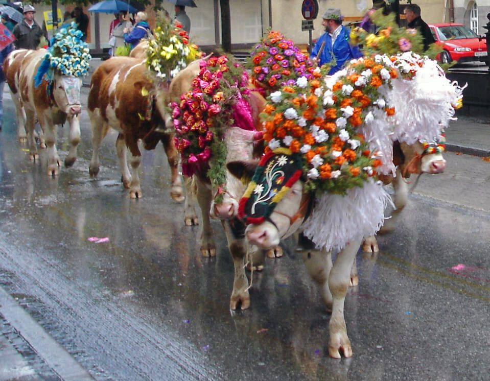
47 - Tunceli, Turkey
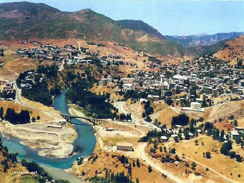
SE of the Munzur Silsilesi mountains.
Tunceli (Zazaki: Dêrsım, is a province in the Eastern Anatolia region of Turkey. The province was named Dersim until 1936 (Dersim meaning 'silver door' in Kurdish), and some still call the region by this name. The province's population is predominantly Zaza. Its adjacent provinces are Erzincan to the north and west, Elazığ to the south, and Bingöl to the east. The province covers an area of 7,774 km² and has a population of 76,401. It has the lowest population density of any province in Turkey, just 9.8 inhabitants/km². Tunceli is the only Turkish province with an Alevi majority.
The name of the provincial capital, Kalan, was then officially changed to match with the province's name. Tunceli is known for its old buildings (though mainly destroyed by Hamidiye Alays in the late 19th century and Turkish army in 1936-37 military operations against the last remaining Armenians and Alevi Derebeys-local rulers), and impressive scenery, especially along the Munzur Nehri
Thursday, August 28, 2008
Wednesday, August 27, 2008
Tuesday, August 26, 2008
Monday, August 25, 2008
Sunday, August 24, 2008
Wednesday, August 20, 2008
31 - Nvadwip, India

Upstream from Calcutta.
Nabadwip (নবদ্বীপ) (also Navadwip, Navadvipa or Nabadwipdham) is a city and a municipality in Nadia district in the Indian state of West Bengal. Its name means "9 islands" in the Bengali language. The islands are named Antardwip (Sri Mayapur), Simantadwip, Rudradwip, Madhyadwip, Godrumdwip, Ritudwip, Jahnudwip, Modadrumdwip, and Koladwip. It is a place of many lilas (or "pastimes of God" in Hinduism) of Sri Caitanya Mahaprabhu. Many pilgrims from origins worldwide adhering to Gaudiya Vaishnavism come to Navadwip every year on pilgrimage and for festivals like Sri Navadvipa-mandala Parikrama and holidays like Gaura Purnima.
Tuesday, August 19, 2008
Monday, August 18, 2008
Thursday, August 14, 2008
Wednesday, August 13, 2008
Saturday, July 26, 2008
26 - Île de Milieu, île Saint-Paul, France
On the E coast of the S Indian ocean island.
In the 1880s Charles Lightoller was shipwrecked here. He accurately describes the island in his autobiography, Titanic and Other Ships. During French rule of Mauritius, Saint-Paul as well as île Amsterdam were administered from Port Louis, but they were transferred to Réunion prior to British invasion of Mauritius.
In 1871 a British frigate, HMS Megaera, was wrecked on the island. Most of the 400 persons on board had to remain upwards of three months on the island.
Lightoller suggested that pirates may have used the island and their treasure could be buried in its caves. There is also speculation that officers from the German auxiliary cruiser Atlantis hid treasure near the entrance of the bay during World War II.
In 1928, an ill-fated spiny lobster cannery was established on Île Saint-Paul. Seven employees of the cannery were abandoned to their fate on the island when the company went bankrupt in 1931; they later came to be known as Les Oubliés de Saint-Paul ("the forgotten ones of St. Paul"). Five died; the two survivors were finally rescued in 1934.

Friday, July 25, 2008
Thursday, July 24, 2008
Wednesday, July 23, 2008
23 - Feng-huang, China
County in W Hunan province.
Fenghuang are mythological Chinese birds that reign over all other birds. The males are called Feng and the females Huang. In modern times, however, such a distinction of gender is often no longer made and the Feng and Huang are blurred into a single feminine entity so that the bird can be paired with the Chinese dragon, which has male connotations. The Fenghuang is also called the "August Rooster" (traditional Chinese: 鶤雞; pinyin: kūnjī) since it sometimes takes the place of the Rooster in the Chinese Zodiac. In the West, it is commonly referred to as the Chinese phoenix.
Tuesday, July 22, 2008
Monday, July 21, 2008
Sunday, July 20, 2008
20 - Chofu, Japan
Outer district of Tokyo, on the bank of Tama-gawa.
Chōfu (調布) is a western suburb of Tokyo, and the main draws are Jindaiji Temple and Jindai Botanical gardens. These twin attractions are next to each other, making a reasonable day trip from central Tokyo. Beyond these two, Chōfu feels like the suburb that it is, particularly on the the weekends when the train platform is crowded with parents and their children.
Saturday, July 19, 2008
19 - Bicoli, Halmahera, Indonesia
On the E peninsula of the big island W of New Guinea. Here's a butterfly native to the island:

Friday, July 18, 2008
Thursday, July 17, 2008
17 - Zamboanga, Philippines
On the tip of Mindanao's western peninsula.
Zamboanga City brings its best foot forward during the popular Fiesta Pilar, celebrated in honor of the city's patron saint, La Nuestra Senora del Pilar de Zaragoza Our Lady of the Pillar of Zaragoza, Spain. A statue honoring the saint is prominently embossed above the façade on the eastern wall of the meter-thick walled fort called El Real Fuerza de Nuestra Señora del Pilar de Zaragoza (also called El Real Fuerza de San José in its early days). This Spanish military fort was built on June 23, 1635, by the Spanish Jesuit priest Fr. Melchor de Vera in defense against pirates and slave raiders. Zamboanga City is one of the oldest cities in the country and is the most Hispanized. It is also one of the largest cities in the world in terms of area, with over 1,480 km², including its 28 surrounding islands. Its recorded population in 2007 was 774,407.
Wednesday, July 16, 2008
Tuesday, July 15, 2008
Monday, July 14, 2008
14 - Warrawagine, Western Australia
On the Oakover River, W of the Great Sandy Desert.
NPR story:
Located on the edge of the Great Sandy Desert in Western Australia, the Warrawagine Station has been one of the winners of climate change, thriving in nearly 24 inches of rain in the past year.
Warrawagine Station is home to more than 20,000 Droughtmaster cattle. The million-mile ranch depends on rainfall to get through the arid summer months, as the majority of the station has a desert-like landscape.

Sunday, July 13, 2008
13 - Victoria Downs, Queensland, Australia
S of Chapters Towers.
Victoria Downs, once Australia's largest pastoral property and the largest cattle station in the world, is synonymous with Sidney Kidman - the Cattle King. In the 1920s, after a malaria epidemic, John Flynn built a hospital on the station which was operated by the Australian Inland Mission until it closed down in 1942. Both the original homestead, which is located some kilometres south of the current Victoria Downs homestead, and the hospital are now listed as part of the National Estate.
Saturday, July 12, 2008
12 - Ulladulla, New South Wales, Australia
The name "Ulladulla" comes from the aboriginal word Nulladulla, which means "safe harbour".
The town gained its first traffic light in the 1990s; one of its most notable landmarks is the Marlin Hotel with its big fluorescent marlin on the roof, which can be viewed from the sea.
Friday, July 11, 2008
11 - Timaru, New Zealand
Timaru has been constructed on rolling hills created from the lava flows of the extinct Mt Horrible volcano, which last erupted many thousands of years ago. The result is that most of the main streets are undulating, a clear contrast with the flat landscape of the Canterbury Plains to the north. This volcanic rock is used for the construction of local "bluestone" buildings.

Thursday, July 10, 2008
10 - Sandell Bay, Macquarie Island, Australia

Feral cats introduced to the island by whalers in the 19th century have had a devastating effect on the native seabird population, with an estimated 60,000 seabird death per year. In June 2000, the last of the nearly 2500 cats were culled in an effort to save the seabirds.
Although seabirds numbers began to rise initially, the removal of the cats caused an explosion in the number of rats and rabbits which together are causing widespread environmental damage. The rabbits too were an introduced species; by sealers in the 1800s as a food source and rapidly multiplied before numbers were reduced to about 10,000 in the early 1980s when myxomatosis was introduced. Rabbit numbers have now exploded to around 100,000 on the island.[4] The rodents feed on young chicks while rabbits nibbling on the grass layer has led to soil erosion and cliff collapses, destroying seabird nests. Large portions of the Macquarie Island bluffs are eroding as a result. In September 2006 a large landslip at Lusitania Bay, on the eastern side of the island, partially destroyed an important penguin breeding colony. Tasmania Parks and Wildlife Service attributed the landslip to a combination of heavy spring rains and severe erosion caused by rabbits.
There are currently plans to conduct the largest eradication program ever by mass baiting the island similar to an eradication program on New Zealand's Campbell Island, but there was an argument over which government, state or federal, will pay the estimated $24 million cost. On 4 June 2007 a media release by the Federal Minister for the Environment and Water Resources, Malcolm Turnbull, announced that the Australian and Tasmanian Governments had reached an agreement to jointly fund the eradication of rodent pests, including rabbits, to protect Macquarie Island's World Heritage values. It is expected to take up to seven years.
Wednesday, July 9, 2008
9 - Rongelap, Micronesia
E of Bikini.
Rongelap Atoll is an island-atoll located in Micronesia. It is a municipality of the Marshall Islands. The Atoll consists of 61 islets with a combined area of approximately 3 square miles (8 km²). Its lagoon covers 388 square miles (1,000 km²). It is historically notable for its close proximity to American hydrogen bomb tests in 1954.
The United States military conducted atmospheric nuclear weapons tests, including hydrogen bomb tests in the Pacific from 1946 through 1958. These tests were primarily in the Bikini Atoll, about 150 miles from Rongelap Atoll. On March 1, 1954, the test of the Castle Bravo hydrogen bomb generated radioactive fallout which killed a crew member of a Japanese fishing boat, the Daigo Fukuryū Maru, and contaminated Rongelap. The inhabitants were forced to abandon the islands, leaving all their belongings, three days after the test. They were relocated to Kwajalein for medical treatment.
In 1957, three years later, the USA declared the area 'clean and safe' and allowed the islanders to return [1]. Evidence of continued contamination mounted, however, as many residents developed thyroid-tumors, and many youngsters died of leukemia.[citation needed] The magistrate of Rongelap, John Anjain, appealed for international help, without significant response.
In 1985, Greenpeace helped evacuate the people from Rongelap and aided their resettlement on the islets of Mejatto and Ebeye on Kwajalein-atoll. Ebeye is significantly smaller than the islands of Rongelap, and joblessness, suicide, and overcrowding have proven to be problems following the resettlement.
In September 1996, the United States Department of the Interior signed a 45 million dollar resettlement agreement with the islanders, stipulating that the islanders themselves will scrape off a few inches of Rongelap's still contaminated surface. However, this is an operation deemed impossible by some critics. Now, however, the Mayor James Matayoshi says on his website that the project has been successful and was telling about a new promising future for the inhabitants and also for the tourists.
Tuesday, July 8, 2008
123 - Queen Maud Land, Antarctica
Home of two S African research stations.
Queen Maud Land is an English translation of Dronning Maud Land, the official name in use by Norwegian authorities and British Antarctic Survey on the part of Antarctica claimed by Norway as a dependent territory, on January 14, 1939. This claim, like all others in the Antarctic, is not universally recognized and is subject to the terms of the Antarctic Treaty System. It has a land area of approximately 2.5 million square kilometers (one million sq mi), mostly covered by the Antarctic ice sheet lying between the British claim, at 20°W and the Australian claim, at 44°38'E. Norway has not officially elaborated as to the northernly and southernly extent of their claim. This explains why the Norwegian claim is illustrated differently from other claims on some maps of Antarctica. It is however generally assumed that the Norwegian claim follows the norms of the other Antarctic claims. The Norwegian claim has been officially recognised by Australia, France, New Zealand and the United Kingdom. The territory is named for Princess Maud of Wales (1869–1938), Queen consort of King Haakon VII of Norway.
Monday, July 7, 2008
122 - Papetoai, Moorea, French Polynesia

Sunday, July 6, 2008
Saturday, July 5, 2008
Friday, July 4, 2008

Thursday, July 3, 2008
Wednesday, July 2, 2008
117 - Kwakoegroa, Surinam
50mi. S of Paramaribo. I'm pretty sure I transcribed it right, but Google turns up nothing. There's a Kwakoe festival in Amsterdam, celebrating Dutch-Surinamese culture, though.
Tuesday, July 1, 2008
116 - Jérémie, Haiti
Main town on the N coast of the southern peninsula.
Monday, June 30, 2008
115 - Izalco, El Salvador
<
In the SW. The city's eponymous volcano (or the other way 'round) is one of the most famous and active in El Salvador.

Here's the town:
Sunday, June 29, 2008

Saturday, June 28, 2008
113 - Golsovia, Alaska
On Norton Sound, S of Unalakleet. Now seems to exist largely as a river name.

Friday, June 27, 2008
112 - Fischer, Texas
Seeds of the community were sown in 1876 with more than 3,000 acres acquired by brothers Herman and Otto Fischer. Herman claimed and stuck with 160 acres, building a small 3-section “dog trot” cabin -- part of it becoming the original Fischer’s store and the hub of “Fischerdale.” Otto, however, thought 3,000 acres would be more suitable for a livestock operation. It makes sense, then, that Herman became known as “Store” Fisher, and Otto known as “Stock” Fisher.
Over the years, Fischer’s store expanded far beyond its mercantile role to also become the community’s post office, “bank” and saloon -- the original 3-section cabin giving way to a larger frame building. At about 1900 it became the frame and tin structure we know today. Never one to miss a business opportunity, “Store” Fischer established a thriving cotton gin across the road at a spot now marked by two cedar trees in the open field.
Progress also brought name changes to Fischerdale, which quickly became Fischer’s Store. However, with the post office came a forced name change to simply Fischer, so the postmark wouldn’t “advertise” the store.
Here's a tractor patent by Fischer resident Kevin Wilson:

Thursday, June 26, 2008
111 - El Toro, California
NE of Laguna Beach.
Before it was decommissioned in 1999, it was the home of Marine Corps aviation on the West Coast. Designated as a Master Jet Station, its four runways (two of 8,000 feet (2,400 m) and two of 10,000 feet) could handle the largest aircraft in the U.S. military inventory. All U.S. Presidents in the post-WWII era have landed in Air Force One at this airfield.
Wednesday, June 25, 2008
110 - Delle, Utah
Delle is a small enclave in Tooele County, Utah, along Interstate 80 near the Bonneville Salt Flats. The town has never had more than a few residents and has served primarily as a filling station along the I-80 corridor (and U.S. Route 40 corridor before it). Since the completion of the freeway the town has essentially become a ghost town.

Tuesday, June 24, 2008
109 - Chama, New Mexico
In the San Juan Mountains, just S of the Colorado line.
Monday, June 23, 2008
108 - Bassett, Nebraska

Sunday, June 22, 2008
Saturday, June 21, 2008
106 - Zeeland, Michigan
20mi. SW of Grand Rapids. Founded by Dutch settlers. Current home of the Herman Miller furniture company.

Friday, June 20, 2008

Thursday, June 19, 2008
Wednesday, June 18, 2008
103 - Whites Valley, Pennsylvania, USA
10mi. NE of Carbondale. Home to an octagonal schoolhouse, built in 1840:

Tuesday, June 17, 2008
102 - Villa Ahumada, Mexico
In Chihuahua, about 100mi. S of El Paso.
Villa Ahumada (officially Miguel Ahumada) is a town in northern Mexico with about 9,000 inhabitants (2008), located in the state of Chihuahua along Highway 45, about 130 km south of Ciudad Juárez and 247 km north of the city of Chihuahua.
The city has several roadside restaurants and burrito stands and is known for its good cheese.
Villa Ahumada entered the international news in 2008 when it was terrorized for several hours by an out of town gang. This was presumably part of the wave of drug-smuggling related violence in Mexico that resulted in about 4,000 deaths between early 2007 and mid 2008. At the night of May 19, 2008, dozens of men drove through town, firing assault rifles and killing the police chief, two police officers and three civilians, and abducting at least 10 people. The remaining policemen then left, and the state and federal governments sent troops to restore order. Officials did not offer a theory about the perpetrators. According to local rumors, the town's drug dealers had been aligned with police and were linked to the Juárez Cartel. After a local drug boss was killed and another arrested, a rival gang was possibly trying to take over the drug trade along the route from Ciudad Juárez to the state of Sinaloa.
Monday, June 16, 2008
101 - Upper Arrow Lake, British Columbia, Canada

Sunday, June 15, 2008
100 - Thompson, Manitoba
On a long spur of the CNR.
The modern history of Thompson began in 1956 when on February 4, a major ore body was discovered by use of an airborne electromagnetometer following ten years of mining exploration in the region. Inco Limited signed an agreement with the Manitoba government covering the construction of the mine, mill, smelter, and refinery, as well as town services. The agreement also required that the company provide financial assistance towards the Kelsey Generating System, and a spur line to connect with C.N's Bay Line near Thicket Portage. Thompson is a planned community named after Inco's chairman, John F. Thompson, and was incorporated as a town in 1967 on Canada's Centennial Anniversary. In 1970 Thompson was incorporated as a city in the royal presence of Queen Elizabeth II, having reached a population of 20,000. A decline in population occurred during the following decades, levelling off around 14,000 people. Thompson came to be known as "The Hub of the North", as it functions as a centre for politics and commerce in the region.
The Tragically Hip wrote a song called "Thompson Girl", apparently set in Thompson, MB. Here they are performing it:
Saturday, June 14, 2008
99 - Sudbury, Ontario, Canada
Just E of Copper Cliff. Wikitravel's "Things to Do in Sudbury" includes this:
Every few hours, the molten smelting waste (called slag) is moved by train to the huge piles in the northwest part of the city. The liquid slag is dumped from the top of the piles, resulting in a spectacular volcano-like spectacle.
The mining company no longer publicizes the location of the slag dumps, so consider yourself lucky if you are able to see it. The best way to see a slag dumping is to befriend a local. They will inform you of the best place to see it from, and if you're lucky, they will accompany you personally!
Friday, June 13, 2008
Thursday, June 12, 2008
97 - Queen Charlotte Islands, British Columbia, Canada
S of the Alexander Archipelago. They always save me when I play my "name islands A-Z" game.
The story of the modern name:
The archipelago was visited in 1774 by Juan Pérez (at Langara Island) and in 1778 by Captain James Cook. In 1787 the islands were surveyed by Captain George Dixon. The islands were named by Captain Dixon after one of his ships, the Queen Charlotte, which was named after Queen Charlotte, wife of King George III of the United Kingdom.
The name Haida Gwaii is of modern coinage and was created as an alternative to the colonial name "Queen Charlotte Islands", to recognize the history of the Haida Nation. "Haida Gwaii" means "our land", while "Haida" on its own means not only "us" but also "people".
No longer in common usage is the more ancient and original name of 'Xaadala Gwayee' or, in alternative orthography, 'Xhaaydla Gwaayaay', meaning Islands on the Xhaaydla, that is to say, Islands on the Boundary between Worlds, 'Worlds' referring here to the forest, sea, and sky; indeed, the coastal villages of the Haida occur along the meeting of forest, sea, and sky.
Wednesday, June 11, 2008
96 - Pico, Azores
Island S of São Jorge.
Pico Island (Portuguese: Ilha do Pico, pron. IPA: ['iʎɐ du 'piku]) is an island of the Azores noted for its eponymous volcano, Ponta de Pico (Pico Alto), which is the highest mountain of Portugal and also the highest elevation of the Mid-Atlantic Ridge.

Tuesday, June 10, 2008
95 - Odendaalsrus, South Africa
In the Orange Free State, between Klerksdorp and Bloemfontain.
It started out in 1912 as a ramshackle collection of farms and a central church that became a town. In April 1946 gold was struck on the farm Geduld near the town. On the 5 December 2000, Odendaalrus was incorporated into the Matjhabeng Local Municipality along with the city of Welkom and the towns of Allanridge, Hennenman, Ventersburg and Virginia. The Kutlwanong location was established about 10 km outside Odendaalsrus to house black people during the apartheid era.
Monday, June 9, 2008
Sunday, June 8, 2008

Saturday, June 7, 2008
92 - Luganba, Congo
Friday, June 6, 2008

Thursday, June 5, 2008
Wednesday, June 4, 2008
Tuesday, June 3, 2008
88 - Hamada Safia, Mali
Monday, June 2, 2008
Sunday, June 1, 2008
86 - Faiyûm, Egypt
Saturday, May 31, 2008
85 - El Minya, Egypt
150mi. upstream from Cairo. The Codex Tchacos, including the recently famous Gospel of Judas, was found by a "treasure-hunter" near El-Minya in the 1970s.
Friday, May 30, 2008
Thursday, May 29, 2008
83 - Çorovodë, Albania
Çorovodë, also written as Çorovoda is the main city of Skrapar, Albania with a population of around 7,000. The city name Çorovoda comes from the Bulgarian: Черна вода (Cherna voda) and means "black water". The Çorovoda river passes through the city and it is also home to a canyon, known as "Pirogosh". Allegedly, two kings, Piro and Goshi, named the cavern.
Osumi river passes through the city too and forms wonderful canyons and caves which are the highest and the longest in Abania. Çorovoda offers many other attractions to everyone who would like to spend some unforgettable holidays. Çorovoda is only 3 hours away from Tirana (the capital).
Some archaeologists believe Çorovoda might be the oldest city in Albania. They have found ruins of some churches and a buried castle in Rovica which might be more ancient than the castle of Berat.
Wednesday, May 28, 2008
Tuesday, May 27, 2008
Monday, May 26, 2008
80 - Zagarolo, Italy
20mi. E of Rome. This flying-saucer-shaped house is apparently at the south end of town.

Sunday, May 25, 2008

Saturday, May 24, 2008
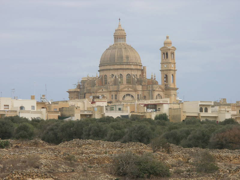
78 - Xewkija, Gozo, Malta
S central town on the island.
The word Xewkija is derived from Arabic and shows that there had been vast fields full of thorns in the past. Xewkija is famous/very well known for its majestic church, The Rotunda, which is dedicated to St. John The Baptist. It replaced an older church. This church is the Seat of the Knights of the Order of St. John. It was built from Maltese stone by local masons and craftsmen. It is the largest in Gozo and its dome dominates the village.
Friday, May 23, 2008
77 - Windmill Hill Flats, Gibraltar
Near the S tip of the peninsula.
At Windmill Hill Flats we find a rather hostile environment: a flat, wind-lashed terrain, with thin, poor stony soil. Despite all this, Windmill Hill is a treasure-house of plant species. In Spring it is a riot of colour, albeit for a brief period. Here we find a number of species which are not found elsewhere on the Rock, including Crocus serotinus salzmannii (Southern Autumn Crocus); Salvia verbenaca (Wild Clary); Echium parviflorum (Small-flowered Bugloss); Plantago serraria (Saw-toothed Plantain); Hedysarum coronarium (Italian Sainfoin); Mantisalca salmantica; Minuartia geniculata (Pink Sandwort); Tetragonolobus purpureus (Winged Asparagus Pea); Lathyrus annuus (Annual Yellow Vetchling). Other important plants found here better than anywhere else on the Rock are Ornithogalum orthophyllum (Star of Bethlehem); Romulea clusiana (Romulea); Gynandriris sisyrinchium (Barbary Nut); Borago officinalis (Borage); Ecballium elaterium (Squirting Cucumber); Echium plantagineum (Purple Viper's Bugloss).
Thursday, May 22, 2008

Wednesday, May 21, 2008
75 - Uncastillo, Spain
In Aragon/Zaragosa, between Pamplona and Huesca. I like how the satellite view of the region looks like a polished slice of especially lively marble.

Tuesday, May 20, 2008
74 - Talavera de la Reina, Spain
On the river Tajo, W of Toledo.
internationally known for its ceramics, which Phillip II of Spain used as tiled revetments in many of his works, such as the monastery of El Escorial. The nickname of Talavera de la Reina is 'The City of Pottery' (La Ciudad de la Cerámica, in Spanish).

Monday, May 19, 2008
73 - St. Louis, Senegal
Northern coastal city.
Saint-Louis was established in 1659 by French traders on an uninhabited island called Ndar. It was baptized Saint-Louis-du-Fort in homage to the French king Louis XIV. It was the first permanent French settlement in Senegal. The fortified factory commanded trade along the Senegal River. Slaves, hides, beeswax, ambergris and, later, gum arabic were exported. In the late 18th century, Saint Louis had about 5,000 inhabitants, not counting an indeterminate number of slaves in transit. "Saint-Louis became the leading urban centre in sub-Saharan Africa”.

Sunday, May 18, 2008
72 - Rochechouart, France
25mi. W of Limoges.
Two hundred million years ago it was the site of impact of one of the largest meteorites ever to hit earth, a monster 1.5km in diameter and some 6000 million tonnes in weight. The traces of this cosmic calamity still attract the curiosity of astronomers, though the only evidence that a layman might notice is the unusual-looking breccia stone many of the region's older buildings are made of: the squashed, shattered, heat-transformed and reconstituted result of the collision
Saturday, May 17, 2008
71 - Queyras, France
In the Alpes Cottoennes; the region nearest to Turin in Italy. Here's a video of some hiking in the region.
Friday, May 16, 2008
Thursday, May 15, 2008
69 - Oisemont, France
Wednesday, May 14, 2008
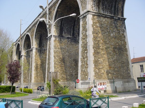
68 - Nogent-sur-Marne, France
Suburb of Paris, just E of the Bois de Vincennes. Home to this handsome viaduct:
Tuesday, May 13, 2008
Monday, May 12, 2008
Sunday, May 11, 2008
65 - Kufstein, Austria
Saturday, May 10, 2008
64 - Jáchymov, Czech Republic
Just S of the German border. As Jachmenstal, a spa-town of the Austrian Empire.
At the beginning of the 20th century, Marie Curie discovered, in tons of pitchblende ore containing uraninite from Joachimsthal, the element radium, for which she won the Nobel Prize in Chemistry. Until the First World War this was the only known source of uranium in the world.
Friday, May 9, 2008

Thursday, May 8, 2008

Wednesday, May 7, 2008

Tuesday, May 6, 2008
60 - Franeker, Netherlands
In Friesland, NE of the Zuider Zee. Great colors in the tidal shadows inside the Friesien Islands.
Famous People from Franeker
Eise Eisinga
François Hemsterhuis
Jan Hendrik Oort
Anna Maria van Schurman
Monday, May 5, 2008
59 - Errill, Ireland
In the SW corner of County Laois. I like the patches of orange in the satellite image of Ireland -- how like the flag!
Sunday, May 4, 2008
58 - Dingwall, Scotland, UK
15mi. NW of Inverness. The birthplace of Macbeth, and current home of the northernmost full-time football squad in the UK.
Saturday, May 3, 2008

Friday, May 2, 2008
56 - Bristol, England, UK
Near the mouth of the River Avon. While I knew that Bristol was home of the "Bristol Sound", aka trip-hop etc., I hadn't realized that seminal trip-hop group Portishead was named for a nearby riverine suburb.
Thursday, May 1, 2008
55 - Acton, London, England, UK
W of Wormwood Scrubs.
The Monty Python sketch 'Bicycle Repair Man' was shot on Churchfield Road, Acton.
Wednesday, April 30, 2008
54 - Zennor, Cornwall, England, UK
On the coast due N of Penzance.

There is a local legend about a mermaid in Zennor.
Mathew Trewella was a good-looking young man with a good voice. Each evening Mathew would sing the closing hymn at the church in Zennor, solo. A mermaid living in neighbouring Pendour Cove was enchanted by the music. She dressed in a long dress to hide her long tail and walked a bit awkwardly to the church. Initially, she just marvelled at Mathew's singing before slipping away to return to the sea. She came every day, and eventually became bolder, staying longer. It was on one of these visits that her gaze met Mathew's, and they fell in love. However, the mermaid knew she had to go back to the sea or die. As she prepared to leave, Mathew said "Please do not leave, who are you, where are you from?".
The mermaid told him that she was a creature from the sea and that she must go back. Mathew was so love-struck that he swore he would follow her wherever she went. Mathew carried her to the cove and followed her beneath the waves, never to be seen again.
It is said that if you sit above Pendour Cove at sunset on a fine summer evening you might hear Mathew singing faintly on the breeze.
At St. Senara Church in Zennor visitors may see a carved bench-end over 600 years old showing the mermaid.
Tuesday, April 29, 2008

Monday, April 28, 2008
51 - Xiinkaupunki (aka Kristiinankaupunki), Finland
180mi NW of Helsinki, on the Gulf of Bothnia. There are not, as far as I can tell, any proper X-placenames in Scandinavia, so I had to make due with the Xmas-style abbreviation. (In Swedish, the town's name is the shorter Kristinestad).
The town shield is basically a map of the place, presumably up-close enough so the blue is the water of the fjord:

Sunday, April 27, 2008
50 - Kapp Wien, Jan Mayen Island, Norway
View Larger Map
On the E coast of the Sør-Jan peninsula. The island is about halfway between Norway and Greenland. A little wikihistory:
The first known discovery of the island was in 1614. There are earlier claims and possible discoveries: Some historians believe that an Irish monk, Brendan, who was known as a good sailor, was close to Jan Mayen in the early 6th century. He came back from one of his voyages and reported that he had been close to a black island, which was on fire, and that there was a terrible noise in the area. He thought that he might have found the entrance to hell.
Saturday, April 26, 2008
Friday, April 25, 2008
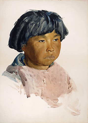
48 - Umanaq, Greenland
View Larger Map
In a fjord on the mid-west coast. Here's an 1896 watercolor of a boy in Umanaq, by Arctic explorer Russell W. Porter:
Thursday, April 24, 2008
47 - Tolvoyarvi, Russia
N. of St. Petersburg, on the Finnish border.
View Larger Map
I like how the terrain becomes much more mottled once you cross over into Finland—an artifact of the different countries' mapping resolution.
View Larger Map
I like how the terrain becomes much more mottled once you cross over into Finland—an artifact of the different countries' mapping resolution.
Wednesday, April 23, 2008
46 - St. Basil's Cathedral, Moscow, Russia
Outside the Kremlin's Eastern wall.
View Larger Map
Wikipedia:
How many of the world's great monuments have attached lore about the architect being blinded/otherwise disabled afterwards? I think there's one about the Taj Mahal too.
View Larger Map
Wikipedia:
The initial concept was to build a cluster of chapels, one dedicated to each of the saints on whose feast day the tsar had won a battle, but the construction of a single central tower unifies these spaces into a single cathedral. A popular legend says that Ivan had the architect, Postnik Yakovlev, blinded to prevent him from building a more magnificent building for anyone else. However, Yakovlev designed the chapel added to the edifice in 1588, four years after Ivan's death, and had therefore not been blinded.
How many of the world's great monuments have attached lore about the architect being blinded/otherwise disabled afterwards? I think there's one about the Taj Mahal too.
Subscribe to:
Posts (Atom)